Skip to content

Shrub fuel volume estimation with photos and height measurement

Bacciu, V.1, Pellizzaro, G.1, Scarpa, C.1

1National Research Council of Italy – Institute for the BioEconomy

Last updated: 25/09/2026

Recommended citation:

Bacciu, V., Pellizzaro, G. & Scarpa, C. 2026. Shrub fuel volume estimation with photos and height measurement. In: Pere Casals, Davide Ascoli, Lena Vilà-Vilardell, Imma Oliveras, Madoka Krick (eds.) 2026. Methods handbook for characterizing fire use behavior, assessing fire effects, and monitoring soil and vegetation responses at the stand level. FIRE-ADAPT project (number 101086416), deliverable D1.1

Indicator

Fuel load: Surface fuel load

Brief introduction

This approach is used to estimate, through photos and height measurement, the shrub fuel volume. Volume refers to the amount of fuel available for combustion. The greater the volume of fuel available, the more intensely a fire will burn. This approach can be also applied to document the effects of the management and the dynamics after it.

Method specifications

Method type

Soft

Hard

Method timing

Before
fire

During
fire

After fire 
(short-term)

After fire
(mid-term)

After fire
(long-term)

Field skills

Low

Medium

Hard

Lab skills

Low

Medium

Hard

Material cost

Low

Medium

Hard

Time cost

Low

Medium

Hard

Calculation expertise

Low

Medium

Hard
Equipment

  • Poles of 2 m

  • A decameter of 30 meters and a rigid meter

  • A camera

  • Digital image software (e.g. Photopea)

Experimental design

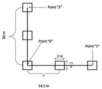
The fuel cover and volume of shrubs are estimated through fixed-area plots. The plots (sample units 2×2 m) are placed in proximity to each other across two linear transects disposed orthogonally (Fig. 1). The orthogonal disposition of the transects permits sampling along two orthogonal guides, avoiding the possible bias due to topographic patterns. The transect length may vary according to several factors, including the minimum size of the sampling area and environmental characteristics. Transect and plot coordinates are recorded with a GPS for future sampling. 

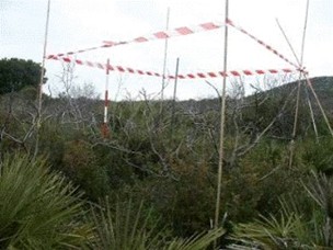
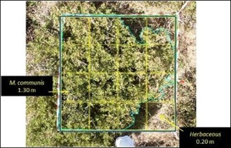
Cover and height of species are collected within the plot (Fig. 2), ideally partitioned into 16 quadrants (Fig. 3).

Methodology

  1. Identify the location of the cross point of two linear transects: set the central point and record the coordinates (Fig. 1).
  2. Trace two orthogonal 30-m transects to North-South and to East-West, intersecting the central point. Record the coordinates of the ends of the transects, called point 1 and point 2. The measuring tape is stretched straight above the vegetation canopy. 
  3. Place five 2 x 2 m plots along the transects at an equal distance of 14.5 m from each other. Their centres were recorded with the GPS, and the boundaries were defined with tape and poles
  4. Cover measurements: For each sampling plot, several digital photos are collected by placing a digital camera with a remote control perpendicular to the ground at about two meters above the plants. The images are imported and analysed to calculate the area covered by each species; the plot perimeter and the perimeter of each species within the plot are digitised, and the cover area is then computed.
  5. Height measurements: Each plot is ideally partitioned into 16 quadrants. In each quadrant, plant height is measured within the plot as the vertical average distance from the soil surface to the top of the branches of the predominant species of each quadrant.

Relation with other methods

NA

Illustrations

Fig. 1 Set up of two linear transects and sampling units (plots)
Fig. 2. The sampling plot
Fig. 3. Species, cover, and heights in the 16 plot quadrants

Data templates

NA

Further information

Bacciu VM (2009). Maquis fuel model development to support spatially-explicit fire modeling applications. PhD Thesis, Dipartimento di Economia e Sistemi Arborei, Università degli Studi di Sassari, Sassari, Italy, pp. 263. [online] URL: http://eprints.uniss.it/1090/